Roadside Slope Monitoring System
As infrastructure ages, its maintenance and management become increasingly more important, and it requires more frequent inspections as the years go by. Roads are an integral part of the infrastructure. Keeping them safe as they age requires proper inspection of all essential elements—the road surfaces, tunnels, and roadside slopes. To do this, Ricoh has automated road inspection systems that combine its original optical systems with AI digital technologies to offer cost-effective, efficient inspection solutions.
Background
Artificial and earthen roadside slopes are major structural components of roadways and are used extensively. Just like other roadway features, roadside slopes have been affected by the weather and have aged significantly. As a result, their safety management has become a societal challenge. Japan's Ministry of Land, Infrastructure, Transport and Tourism (MLIT) issued Road Earthwork Structure Inspection Procedures in 2017 that mandate inspections in areas that were not previously compulsory. Now the parties responsible for the roads—prefectures, cities, towns, and villages—are taking an interest in the maintenance and management of the roadside slopes.
Civil engineers regularly climb up steep roadside slopes to conduct a visual inspection. This intensive and dangerous work requires climbing numerous, sometimes lengthy slopes, which entails the significant risk of falling from high and steep locations.
Using technology to increase inspection efficiency
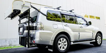
Ricoh is developing a vehicle-mounted Roadside Slope Monitoring System that automatically captures and measures slope conditions in fine detail. Simultaneously, Ricoh is automating related workflow processes, including photo data analysis and creation of records. This efficient and effective slope inspection system will allow for more slopes to be inspected with increased quality. Civil engineers will only need to manually check those areas where high-risk damage or degradation has been detected through analyzing the photographic data.
Technical highlights
1. Covering a wide area of slope in a single shot at high definition
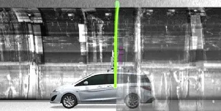
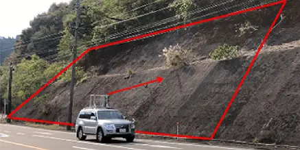
The measurement system features multiple line-sensor cameras and LiDAR (Light Detection and Ranging). A single image can cover a tall and wide slope area in high definition.

2. Identifying deformations through image measurement
Multiple line sensor cameras make it possible to capture roadside slopes to create panoramic images of unlimited lengths. By magnifying these images, visible deformations such as cracks can be identified.

3. Using 3D measurement to track changes in slope shapes
While images are recorded, LiDAR concurrently records the contours of the slopes in 3D, revealing the cross-sectional shapes that cannot be seen from 2D images. These images can spot symptoms of a potential collapse, such as lifting and swelling.

4. Extracting anomalies by AI
AI is used to automatically detect anomalies, including crevices, peels, and cracks, providing an overall image of the slope's general deterioration. Where necessary, close-ups can be output at high resolution for closer analysis. In addition, iterative scans and photos will show chronological changes in anomalies, giving planners the information needed for effective inspections.

Ricoh's vision
As well as utilizing Ricoh-developed optical technologies and systems for the maintenance and management of infrastructure, including roadway pavements and tunnels, the Company has been further developing technologies that can be applied to this infrastructure. The applications now extend to roadside slopes.
By developing systems to monitor the infrastructure, Ricoh will continue to provide solutions to resolve a range of challenges posed by the aging of our infrastructure and declining labor force.
Related information
Related technologies
Sorted by
product type